STATE REGION...WILL BE MOVING INTO THE FOUR STATE REGION WEDNESDAY
INTO WEDNESDAY NIGHT. THIS DISTURBANCE WILL HAVE MUCH MORE
MOISTURE TO WORK WITH AND MUCH MORE IN THE WAY OF COLDER AIR AS
WELL. WHILE THE STORM SYSTEM IS STILL SEVERAL DAYS AWAY...IT
APPEARS THAT SIGNIFICANT SNOW AND ICE ACCUMULATIONS WILL BE
POSSIBLE FOR THE REGION WEDNESDAY INTO WEDNESDAY NIGHT. THE
EVOLUTION OF THIS STORM SYSTEM WILL CONTINUE TO BE MONITORED
CLOSELY AS THE EVENT NEARS.

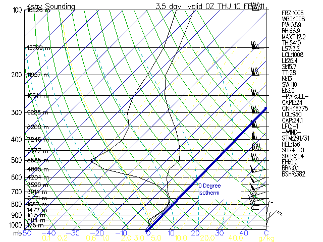
The 12Z forecast sounding for Shreveport indicates that for areas where temperatures are greater than 32 degrees precipitation would be in the form of rain. Areas where temperatures are <32 degrees precipitation would be in the form of freezing rain.
The 00Z Soundings soundings indicate a snow event except for areas south of a Tyler to Shreveport to Memphis line. In this area look for a freezing rain event as the 1000 to 500 MB thickness contour will be greater than 5400 decameters.
No comments:
Post a Comment