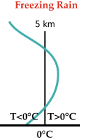
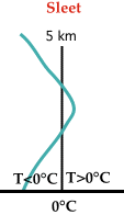
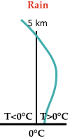
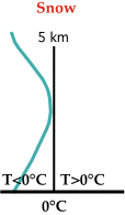
There are four types of soundings associated with the four different types of precipitation (mentioned above). In the following diagrams, the blue line represents the temperature profile of the atmosphere and the black line represents the 0C isotherm (a line of equal temperature). When the blue line is to the right of the black line, it means the atmospheric temperature is warmer than 0C, but when the blue line is to the left of the black line, it means the atmospheric temperature is colder than 0C.
 | Freezing Rain: A shallow layer of cold air lies below a layer of warmer air, which completely melts all ice particles as they pass through. When the raindrops enter the shallow layer of cold air, they supercool and freeze instantly on contact |
 | Sleet: The warm layer is very shallow so ice crystals only partially melt as they pass through. Once they enter the cold layer below, they freeze again and strike the ground as ice pellets, or sleet. |


No comments:
Post a Comment